This walk climbs gently to Deer Hill Reservoir returning via Cop Hill and Helme with extensive views over Meltham and surrounding area.
- Distance – 6 miles
- Time – 3 hours
- Route Type –Moderate
Download
- PDF: A Fair Cop
- Word: A Fair Cop
The route
From the car park at the rear of the Carlile Street, head towards Huddersfield Road passing between the Town Hall and the Carlisle Institute, both built by early benefactors of Meltham. The Institute by J W Carlile in 1891 and the Town Hall by Edward Book in 1897.
Note the five listed cottages opposite the Co-Op.
Turn left and at the cross roads in the centre of the village turn left to cross Huddersfield Road at the zebra crossing. Immediately turn right and cross Wessenden Head Road and take the next left into Greens End Road.
The first church on this site was illegally consecrated in 1651 during Cromwell’s reign by the exiled Irish Bishop of Elphone. The nave of the present church was built in 1786 with the bell tower added in 1835. A carillion of bells were fitted in 1878 thanks to the generosity of Edward Book, grandson of the founder of Meltham Mills.
Pass the front of the church and continue past two further roads to the left to take the last left turn at the road T-Junction to walk the length of Millmoor Road.
The first church was built in 1651, consecrated unusually during the commonwealth. The new church was built in 1786, the tower and transept were added in 1835, bells in 1836, chancel 1877 and a carillion for hymns in 1878. On the left the parish church hall was built as a school in 1823 with the school house next to it.
The road ends at a T-Junction with a wide track opposite.
The buildings at the T-junction were part of early 19thc New Bridge Mill and were key workers homes. The mill was occupied by West Riding Brewery till a fire in 1985 destroyed it.
Walk ahead along this track and after the last farm on your right, turn right 100 yards after onto the catchwater track just before the bridge and a gate leading on to the moor. The catchwater was built about the same time as Blackmoorfoot and Deer Hill reservoirs, full in 1876 and 1875 respectively.
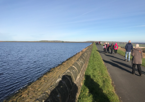
Follow the path round and drop down two stone steps along the catchwater embankment, climb the steel steps to cross the disused weir and the water gates. Turn right and walk ahead for about half a mile. Climbing the stone stiles at the two bridges. At the third bridge, turn left up a walled track (Hassocks Lane). Go through the wooden gate stile at the head of the track and turn right to walk up a cindered track. Turn left at the gate at the top and follow the road round onto Deer Hill reservoir embankment.
Walk halfway along the second side and down the steps onto the intermediate level. Turn right on the grassy path and walk ahead to the corner, then down a few more rough steps and head forward to a wall stile. Walk across two fields on the rough track and at the road, turn left and follow this down to the road junction at Slaithwaite Road.
Up on the left at the road junction is Queen Mary’s farm, named after she stopped there briefly when passing through Meltham in 1912.
Walk straight across onto a track to a further junction at the Wills O Nat’s Inn. Turn right on the road then shortly after, turn left onto a bridle track which skirts below Meltham Cop.
William, Son of Nathanial owned the New Inn which became known as Wills O Nat’s. At the road, turn right over the bridge and take the second path on the left through a gap in the wall down through Orange Wood to cross a field to a gate at the road in Helme. (To avoid this sometimes muddy path you can walk down the road to reach Helme) The Brook family built both the Church and the School in Helme and lived at Manor Croft to the left of Helme Fold.
Walk into Helme Fold then onto the tarmac path which passes the school on the right and the church on the left. Continue ahead on the left path at a junction to pass between two houses and down a track. Cross the road into a track leading to a field. Walk down the left side of the two fields and once over the wooden stile, cross the track ahead through the gate stile to walk down a field. Climb the stile and drop down onto Meltham Greenway. Turn right to the end of the Greenway where it enters an estate road. Where the road bends to the right, keep to the footpath on your left and follow it to its end past the side of the supermarket.
Turn left at the end where it meets Slaithwaite Road and turn left to head back to the village passing the Victoria Park Public House on your left. At the top of the hill, turn left and cross at the zebra crossing opposite the Co-Op to return to the car park.