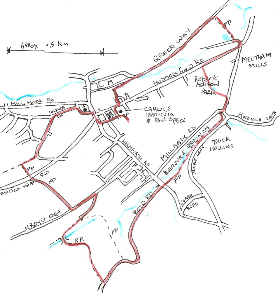
A circular route following some local footpaths within half a mile radius of the village centre.
- Distance – 4 1⁄2 miles
- Time – 2 1⁄4 hours
- Route Type – Moderate
Download
- PDF: Meltham Meander
- Word: Meltham Meander
The Route

From the car park at the rear of the Carlile Street, head towards Huddersfield Road passing between the Town Hall and the Carlile Institute, both built by early benefactors of Meltham. The Institute by J W Carlile in 1891 and the Town Hall by Edward Book in 1897.
Note the five listed cottages opposite the Co-Op.
Turn left and cross Huddersfield Road. Continue to the road junction and cross the road to walk in front of the Church along Greens End Road.
The first church on this site was illegally consecrated in 1651 during Cromwell’s reign by the exiled Irish Bishop of Elphone. The nave of the present church was built in 1786 with the bell tower added in 1835. A carillion of bells were fitted in 1878 thanks to the generosity of Edward Book, grandson of the founder of Meltham Mills.
After passing the church, take the second left up Colders Lane and continue along the pavement for some 300 yards. Where the pavement ends continue straight ahead into a narrow surfaced road which gives way to a grass lined footpath. At this point, turn left into a narrow walled footpath.
The road we have just left was the original route from the village which was superceded when Wessenden Head Turnpike was built in 1820s. Some cottages date back to 1761.
At the top of this path cross Wessenden Head Road and enter the path directly opposite. Follow the unsurfaced track to its Junction and turn left to walk down, passing the Methodist and C of E cemeteries on your left. Turn next right along Hebble Lane which is initially surfaced then descends to a cobbled track.
Go through the gate stile on your right and follow the path down to the bottom corner of the mill dam. Turn left over the footbridge and left again alongside the wall to climb past an isolated farmhouse, Intake Farm, to reach the junction with Royd Road.
The dam near the footbridge used to feed the former dyeworks in the valley below. The area behind the dam known as Royd Edge Clough is a popular picnic spot in summer. The term ‘Intake’ describes farmland wrested from moorland and maintained with difficulty against the moorland vegetation. At the top of the lane through a wall stile is Royd Wood. Good views here over Meltham Mills, towards Magdale and Castle Hill.
Walk down Royd Road which winds past cottages and woodland to reach the main Meltham to Holmfirth Road. Cross the main road to enter and walk the length of the Pleasure Grounds.
The Pleasure Grounds were given to the village by Edward Brook. The grounds originally featured a duck pond, waterfalls and ornamental gardens.
The shop at the end of the Pleasure grounds was built by Jonas Brook, second son of the founder of the factory buildings across the road. The shop was originally built to house the first people’s Co Op, opened in 1826. It preceded the Rochdale pioneers Co-operative by 18 years.
Cross in front of the shop and walk along Meltham Mills Road. Just after the houses on your left, turn left through a stone entrance into Robert Ashton Memorial Park. Follow the path keeping right past the duck pond to emerge onto the park drive, with the former Meltham Hall on your left. Turn right to head down towards the park entrance gates. (At this point you can turn left and head back to the village up the main road).
Meltham Hall was built by William Leigh Brook. The house is now private apartments but for a long period was let to David Brown Tractors as their training school and Social club.
Turn right and walk down the pavement passing the entrance to Meltham Mills Church and its former vicarage by the side of the road.
Meltham Mills Church is a good example of early Victorian Gothic and is cruciform in plan. The interior of the Church has beautiful stained glass windows, many as memorials. Its benefactor James Brook died in 1845 before its completion.
Keep to the pavement on the main road passing the road to Meltham Mills and Bent Ley Road on your right. Walk on for 200 yards to where the road bends slightly to the right. Carefully cross the road here to enter the Meltham Greenway.
Part way on the Greenway, a short detour can be made to see Folly Dolly Falls (a local waterfall) by passing through a gap in the wooden fence on your right and then through a gate stile on your right to the viewing area.
Stay on the Greenway until it emerges into an estate road. Keep left and where the road bends right, take the footpath on your left. Go straight ahead where the path forks up a ramp to pass by the side of the Supermarket and its car par to emerge on Station Street. Turn left to head back to the village centre passing the Victoria Park public house on your left where the road bends.
Follow the pavement round to the left to cross the road at the zebra crossing in front of the Co-op and return to the car park at the rear of the Carlile Institute.
It is strongly advised that walkers follow the route instructions carefully, particularly where crossing private land and comply with the countryside code at all times.