This walk climbs steadily to Blackmoorfoot through Helme onto the Catchwater returning down Royd Edge.
- Distance – 7 miles
- Time – 3 ½ hours
- Route Type –Moderate
Download
- PDF: Reservoir Royd Ramble
- Word: Reservoir Royd Ramble
The route
From the free car park at the rear of the Carlile Institute, walk forward onto Huddersfield Road. Cross the road at the zebra crossing opposite the Co-Op, turn right and after 100 yards turn left into Park Lane. Follow the lane round to the left then bear right to walk down till overlooking the supermarket. Turn right down the ramp, walking forward onto the estate road, keep to the right until you enter the Meltham Greenway path. Walk down the Greenway for 1⁄4 mile till you see a gap in the fence leading to a gate stile.
To the right through a stile is the path to Folly Dolly Falls (a local waterfall) and worth a short detour.
Go straight ahead to the right of the field boundary and over a stile. Turn right to cross a small footbridge. Turn left uphill to a gap stile in a wall by a holly bush. Walk ahead to the sign, turn right and walk uphill to the next sign then bear right to walk with the house boundary fence on your right to a gap stile to the tarmac drive. Follow the drive uphill, round to the left onto the level, till you pass a house on the left and come to where the drives to other houses meet. Turn right back on yourself on a track through a farm gate, up and round to the left onto the level, walking the same direction as before, but higher up.
To your right you can see Castle Hill and Emley Moor mast. To your left is Meltham Mills then Meltham, Helme and Blackmoorfoot reservoir embankment with Harden Moss, Holme Moss mast, West Nab, Deer Hill and Meltham Cop behind.
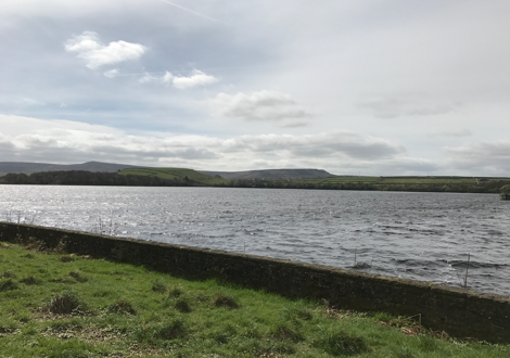
Walk ahead, passing through a gap in a low wall to the left of an electricity pole and along a drive to a road. Turn right, ignore the immediate footpath sign, walk on the road for half a mile and turn off left at the next stile to the left of a gate. Follow an indistinct rough path keeping a wall on the right till you cross a stile, to the right of a wall corner. Follow path round to the right through a metal gate, then turn left down a short steep slope to arrive at the corner of Blackmoorfoot reservoir. The reservoir was filled in 1876. You can walk round part of its edge but not all the way round it.
Cross onto the embankment on the track and pass through a stone wall stile on your left to follow the track down towards the buildings over the footbridge. Just after the cottages, turn left through a stile passing adjacent to their gable to follow a path downhill through Orange Wood to a small plank over a stream. Cross it and walk ahead to a stile. Cross the next field, passing close to a pylon (this can be boggy), to a stile to the right of a gate. Walk towards the spire, into a walled track at a gate. Just before the track bears right to the cottages, take the gate stile on the left, cross the left side of the field and pass through a gate stile to a road. Cross the road, climb a few steps and walk with the church boundary wall on your left to a tarmac path.
Helme Church was built by Charles Brook in memory of his youngest son Charles in 1859. Helme school was built in 1873 in memory of Charles Brook (Senior).
Turn right, pass the school and private entrance to Helme Hall on your left, then turn left over a stile at the left of a gate. Walk ahead over the fields with a wall on your left, till you reach the corner of a field just past the back of a white farmhouse. Helme Hall, passed to your left, was built for the Carliles in 1887 and its stables, best seen looked back at past the end of the trees, have also been renovated.
Turn right over the stile to walk up a field with a wall on the right. Turn left at the top over the stile and follow a track on and gently uphill to a further track T-junction near a white doored barn. Keep right on the track till it crosses an estate road into another track where it emerges onto Slaithwaite Road.
This wall was part of the boundary of Colne and Holme Valley Isolation Hospital built in 1904. After extensions it became a HRI convalescent annexe till 1968.
Cross the road, turning right and left up Hassocks Road (follow the bridleway sign) and walk up the road into a walled track. Turn left at a stile, just before the catchwater bridge, onto a path.
These paths are provided at the discretion of the Water Authority and should be used with care.
Climb over stiles, cross a track, onto a further track arriving at the water gates. Cross the first set and walk ahead up the steps to a small gate. Bear left on the path, over large stepping stones, round to a track. Turn left, then before reaching the gate at the catchwater, turn right and walk up a stony track on the edge of the moor to a gate stile into Wessendenhead Road. Walk up the road past the cattle grid then, just past a seat, turn back left through a sign posted gate stile at a location known locally as Wall Corner. Walk down with the wall on your left through two gate stiles and passing an old building on the right, till you come to some gates.
Climb the stile to the left of the gate, then turn left through the track gate. Follow this track ahead into a less used track as it runs along the top edge of Royd Edge Clough, till it eventually becomes a tarmac road. Just after a road (Hebble Lane) comes in from back right, turn left through a gate stile into a field (allotments). Walk down the right side through another gate stile then cross an estate road to another path and a further gate stile. You emerge into a road, Tinker Lane on a bend. The house at the bottom of Tinker Lane is called Bent House, part of which is the home of Meltham and Meltham Mills Band.
Turn right, walk to the bottom and turn left to follow Holmfirth road back to the centre of Meltham