This walk climbs steadily to a high level, contours the Wessenden Valley returning via Deer Hill reservoir.
- Distance – 9 1/2 miles
- Time – 5 hours
- Route Type – Challenging
Download
- PDF: Wessenden Way
- Word: Wessenden Way
The route
From the car park at the rear of the Carlisle Street, head towards Huddersfield Road passing between the Town Hall and the Carlisle Institute, both built by early benefactors of Meltham. The Institute by J W Carlile in 1891 and the Town Hall by Edward Book in 1897.
Note the five listed cottages opposite the Co-Op.
Turn left towards the centre of the village and at the cross roads turn left to cross Holmfirth Road at the zebra crossing. After the crossing walk left for 150 yards to pass the post office and fire station before turning right to walk up Tinker Lane. Where the road turns right, turn left onto a footpath. Follow it crossing an estate road, then walk up the path on left side of the allotments to emerge onto Calmlands Road. Turn right and climb this road which then becomes a track. Continue up the stony track between a wall and a fence (boundary to a pasture reclaimed from a quarry) till you are faced with two gates across the track. Pass through the gate on the left then immediately after climb the wooden stile on your right.
The building near the gates was where ganister, coming down on small railway wagons from quarries higher up the valley, was transferred onto road vehicles. It was essential in the making of Meltham brickwork’s refractory products.
Continue uphill through gate stiles on a footpath with a wall on the right till you reach a road.
The view back from this point, known locally as ‘wall corner, though less extensive than that from the summit of West Nab, still covers a considerable area. A short detour can be made up to the trig point summit on West Nab by following a path just after the ‘Cock Crowing Stone’.
Cross the road and walk uphill then level for 1 1⁄4 miles to turn right at a gate signed Wessenden Head into a broad track downhill to the Wessenden valley reservoirs.
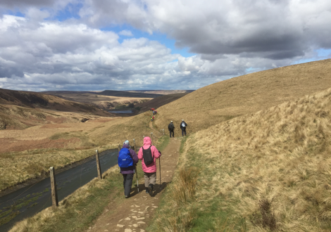
Straight ahead on the skyline before you turn down the track, is the approach to the top of Black Hill. The view down the valley is of the top reservoir, Wessenden Head.
Pass the first reservoir and its spillway, cross a wooden bridge and continue downhill till you bear down to the right to a simple plank bridge. 40 yards after the bridge, bear steeply up to the right on a narrow path for 25 yards to meet another contour path on the hillside. Turn left onto this path and follow it, contouring along the hillside in and out of cloughs, eventually onto, after about 11⁄4 miles a concessionary path at the side of a disused catchwater. Finally, 11⁄4 miles further on, it becomes a track at the side of a working catchwater. Follow this past the white shooting lodge onto the reservoir embankment.
In the Wessenden valley you will see Wessenden, followed by Blakely and the Butterley reservoirs. Later on there are views over Marsden and then over the Colne Valley.
Halfway along the second side of the reservoir, turn left down the steps to the intermediate level. Turn right on the grassy path and walk ahead to the corner, then down a few more steps to a wall stile and then across two fields on a track. Turn left at the road, then almost immediately turn right into a field track. Follow this down hill, bearing right past a gate till you reach another gate at a wide unsurfaced road.
Turn left and pass through a gate stile and continue down hill till you meet a tarmac road at a bend. Turn right on the road, past cottages know as Panna then turn left at the next road junction to walk the length of Millmoor Road back towards the centre. Just past the Methodist Chapel turn right to walk round by the church to reach the centre of Meltham. Walk to the zebra crossing and turn left then right down Huddersfield Road back to the car park at the rear of the Carlile Institute.